|
|
Post by Steve on Jun 18, 2007 23:41:32 GMT -5
Lambton's third railway was the St. Clair branch of the Canada Southern Railway. This branch line of the C.S.R. (or CASO) mainline between Niagara Falls and Windsor ran from the junction in St. Thomas and entered Lambton County east of Alvinston and ran east-west to the St. Clair river at Courtright. It was also the first major line to be abandoned and disappear from Lambton about 1960. But it spawned a string of settlements that survive to this day, including Courtright, Brigden, Inwood, and Alvinston... and a few that survive in name only; Kimball, Corey, Holmesdale, Glen Rae and Weidman.
The St. Clair branch also included two branches of it's own; one that ran north into Petrolia and another that branched off at Oil City and ran south, through Oil Springs to Eddys Mills. These two branches formed their own local circuit which, at it's busiest, saw four trains in each direction between Petrolia and Oil Springs daily!
Imagine a time, before cars or even decent roads, when you could catch a train from Eddy's Mills to Petrolia for a day of business, or shopping and return that same evening!
|
|
jeremy
Junior Member

Posts: 50
|
Post by jeremy on Mar 26, 2011 13:59:14 GMT -5
Incorporation of the Canada Southern Railway and its Precursors Statutes of the Province of Canada 1857 An Act to incorporate the Fort Erie Railway Company books.google.ca/books?id=IAcvAAAAIAAJ&dq=%22An%20act%20to%20incorporate%20the%20fort%20erie%20railway%20company%22&pg=PA610#v=onepage&q=%22An%20act%20to%20incorporate%20the%20fort%20erie%20railway%20company%22&f=falseCharter to build a railway between Fort Erie and Chippewa, with a branch to Port Robinson (I think they meant Chippawa, near Niagara, rather than Chippewa, near Kingston) Statutes of the Province of Canada 1863 An Act to amend the Act incorporating the Fort Erie Railway Company, and to change the name of the said Company to The Eric and Niagara Railway Company Assented to 15 October 1863 books.google.ca/books?id=hGCuAAAAMAAJ&dq=The%20Erie%20and%20Niagara%20Railway%20Company%20Act%20ot%201863&pg=PA307#v=onepage&q&f=falseCharter to build a railway between Fort Erie and Niagara Statutes of the Province of Ontario 1868 An Act for the Incorporation of the Erie and Niagara Extension Railway Company Assented to 28 February 1868 books.google.ca/books?id=-GiuAAAAMAAJ&dq=The%20Erie%20and%20Niagara%20Extension%20Railway%20Act%20of%201868&pg=PA82#v=onepage&q=The%20Erie%20and%20Niagara%20Extension%20Railway%20Act%20of%201868&f=falseThe guys at the Erie and Niagara Railway said “Hey, wouldn’t it be a great idea to have a railway between Fort Erie and Amherstburg?”, and rather than building it themselves, they had a separate company set up for the job. Statutes of the Province of Ontario 1869 An Act to amend the Act incorporating the Erie and Niagara Extension Railway Company, and to change the name to the Canada Southern Railway Company Assented to 24 December 1869 books.google.ca/books?id=VMwvAAAAIAAJ&lpg=PA83&ots=tNe3eYRcV1&dq=An%20Act%20to%20amend%20the%20Act%20incorporating%20the%20Erie%20and%20Niagara%20Extension%20Railway%20Company%2C%20and%20to%20change%20the%20name%20to%20The%20Canada%20Southern%20Railway%20Company&pg=PA83#v=onepage&q=An%20Act%20to%20amend%20the%20Act%20incorporating%20the%20Erie%20and%20Niagara%20Extension%20Railway%20Company,%20and%20to%20change%20the%20name%20to%20The%20Canada%20Southern%20Railway%20Company&f=false “Branch line” extending to the St Clair river authorized. An Act to confer further Corporate Powers on the Canada Southern Railway Company. Statutes of the Province of Ontario 1872 Assented to 2 March 1872 books.google.ca/books?id=Ke2uAAAAMAAJ&dq=An%20Act%20to%20confer%20further%20corporate%20powers%20on%20the%20Canada%20Southern%20Railway%20Company&pg=PA123#v=onepage&q=An%20Act%20to%20confer%20further%20corporate%20powers%20on%20the%20Canada%20Southern%20Railway%20Company&f=false Lines to St Clair River and to Chatham authorized, with completion required within 4 years. An Act respecting the Canada Southern Railway Company Statutes of the Province of Ontario 1873 Assented to 29 March 1873 books.google.ca/books?id=vAqvAAAAMAAJ&q=%22An+Act+respecting+the+Canada+Southern+Railway+Company%22+1873&dq=%22An+Act+respecting+the+Canada+Southern+Railway+Company%22+1873&hl=en&ei=qlKNTbfLHILKgQfCk6WrDQ&sa=X&oi=book_result&ct=result&resnum=1&ved=0CCsQ6AEwAA(snippet view only - can anyone find a hard copy and scan this Act?) An Act respecting the Canada Southern Railway Company Statutes of the Province of Ontario 1874 Assented to 24 March 1874 books.google.ca/books?id=QcKwAAAAMAAJ&dq=%22An%20Act%20respecting%20the%20Canada%20Southern%20Railway%20Company%22&pg=PA306#v=onepage&q=%22An%20Act%20respecting%20the%20Canada%20Southern%20Railway%20Company%22&f=falseRegarding rolling stock and telegraph lines for corporate use. Acts of the Parliament of the Dominion of Canada An Act respecting the Canada Southern Railway Company Assented to 26 May 1874 books.google.ca/books?id=g_4uAAAAIAAJ&dq=%22Canada%20southern%20railway%22&pg=PA302#v=onepage&q=%22Canada%20southern%20railway%22&f=falseLine to St Clair River, and to Amherstburg on the Detroit River have been constructed, fulfilling the requirements that they be finished in 4 years. Acts of the Parliament of the Dominion of Canada An Act to authorize the "Canada Southern Railway Company " to acquire the "Erie and Niagara Railway," and for other purposes Assented to 8 April 1875 books.google.ca/books?id=M_4uAAAAIAAJ&lpg=PA50&ots=BS3gg08qmV&dq=%22whereas%20the%20canada%20southern%20railway%20company%20has%20petitioned%22&pg=PA50#v=onepage&q=%22whereas%20the%20canada%20southern%20railway%20company%20has%20petitioned%22&f=falseThis seems to have been a case of the child corporation swallowing the parent.! |
|
jeremy
Junior Member
Posts: 50
|
Post by jeremy on Apr 3, 2011 18:09:39 GMT -5
Maps of the Canada Southern Railway’s St Clair branch from the early part of the 20th century (e.g. here), after the line had been taken over by the New York Central, and was being run by the Michigan Central Railway, show the existence of a station at Corey, 1.36 miles north of Petrolia Junction and 3.52 miles south of Petrolia itself (see the full timetable here). A.J.Johnston’s book “Lambton County Names and Places” (see here) contains the following brief entry on Corey “A station and post office on M. C. R. just south of Petrolia. Named after Harrison Corey, a prominent oil man of Petrolia. It no longer operates as a post office, but is a way station of the above road.” A civil map of Lambton County from the period between 1940-1951 here, shows Corey as being on Shiloh Line. Corey was never a town or even a village. A way station is a small railway station between the principal stations or a station where the train stops only on a signal - the timetables for the MCR list Corey as a “flag stop”. Certainly, the railway wouldn’t stop there just for the convenience of the local post-office, so why did it? Harrison Corey (28 June 1840- 28 November 1905) was not just a local figure, but a nationally prominent and extremely wealthy man whose company, founded as H. Corey (later H. Corey and Son etc) extracted and refined oil, petroleum products, and even extended as far as the manufacture of nitroglycerine (see profile here). However, large railroad companies did not name stations after you just because you were prominent - there was usually some other relevant reason. For example, the Grand Trunk named Kingscourt after the Kingstone’s family house of the same name not just to honour them, but for the very practical reason that the Elarton Salt Works Tramway, owned originally by the Kingstones, ended at that exact point. It may be a coincidence, but the currently operating Corey East Field (see here and scroll down...) is precisely 3 km to the east of the former site of Corey, at Shiloh Line and Oil Heritage Road. It seems reasonable to conclude that that the stop at Corey was named for a loading terminal for the Corey’s oil fields at that location. So far, I haven’t found out anything specific about the dates of Corey’s existence. However, since it very much existed only as an intersection between Corey’s oil business and the Michigan Central Railway, it is significant that it is not shown on the MCR’s timetable for 27 May 1894 ( link), but does show up in the later one for 15 October 1916 ( link ). Similarly, for an end date, we can reasonably conclude that Corey disappeared between 24 April 1949, when it appears on the timetable ( link), and 25 September 1949, by which time it had disappeared ( link). edit by admin: clean up urls |
|
jeremy
Junior Member
Posts: 50
|
Post by jeremy on Apr 5, 2011 21:38:28 GMT -5
Maps of the Canada Southern Railway’s St Clair branch from the early part of the 20th century (e.g. here ), show the existence of a station at Holmesdale, 9.7 miles west of Alvinston and 3.21 miles east of Oil City (see the full timetable here). Like Weidman, Glen Rae, Corey and Kimballs, it wasn’t a regularly serviced station, but was a “flag stop”. A.J.Johnston’s book “ Lambton County Names and Places” ( see here ) contains the following brief entry on Holmesdale ”At one time a stave mill village on the M. C. R., three miles east of Oil City, called after Mr. Holmes of the firm of Holmes, Moore and Courtright.” A civil map of Lambton County from the period between 1940-1951 ( here ) appears to show Holmesdale on Wanstead Rd. So far, I haven’t found out anything specific about the dates of Holmesdale’s existence. However, it is not shown on the MCR’s timetable for 7 June 1891 ( here ) but does show up for the slightly later one for 27 May 1894 ( here ). Similarly, for an end date, we can reasonably conclude that Holmesdale disappeared between 24 April 1960, when it appears on the timetable( here ), and 30 October 1960, by which time it had disappeared ( here ). It other words, it lasted, in name at least, until the rails of the former Canada Southern St Clair branch were pulled up in 1960. The Sarnia Observer for 4 April 1890 ( here ) reports that the firm of Holmes, Moore and Courtright had erected a shanty on the former property of Mr. Fury and engaged men to make elm “bolts” that would then be carted into Inwood for manufacture into staves. Holmes, Moore and Courtright seem to have had their fingers in many pies, from cattle ( here ) and pigs ( here ) to railroad construction ( here ) There is actually a minor trace of Holmesdale at (or at least near) the site of the original station. Steve has taken this picture of a mile marker salvaged by an adjacent property owner at Holmesdale, with the former CASO right of way in the background. 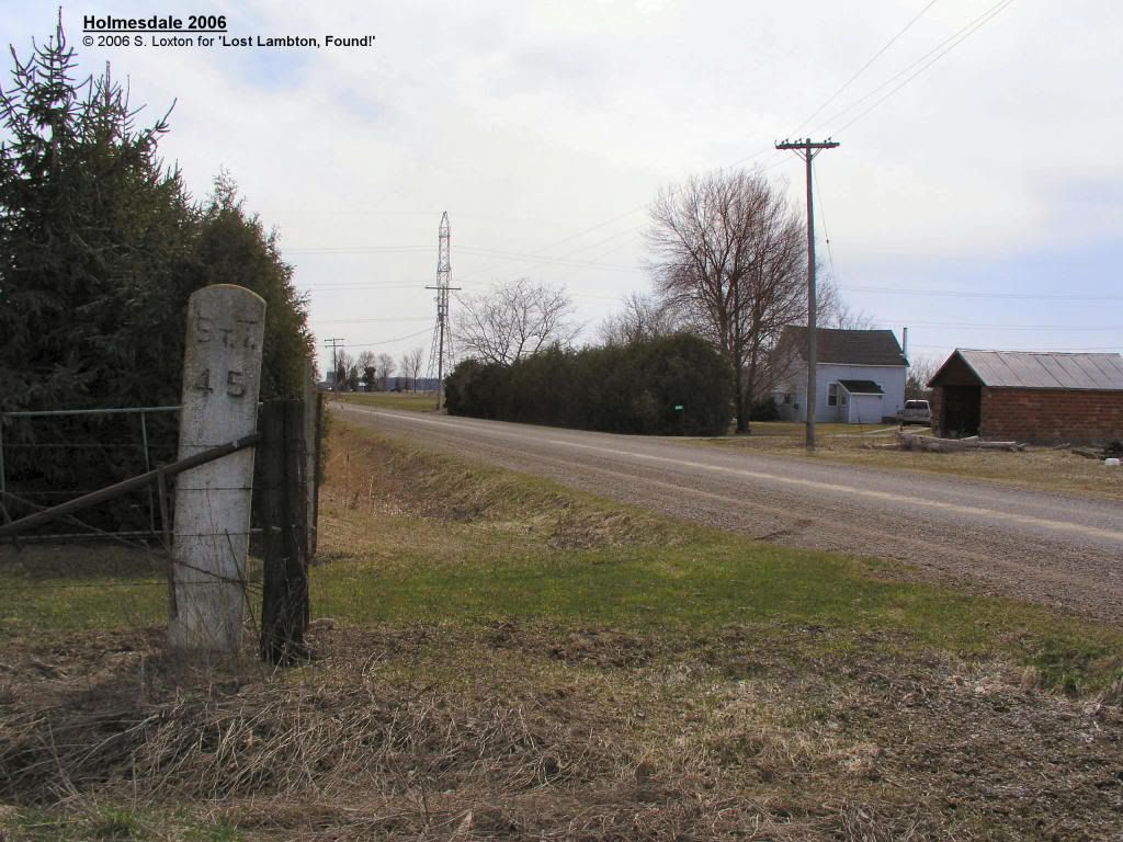 Holmesdale also plays an interesting part in the folklore of Lambton county, in an episode that combines the best elements of a soap opera and America’s Most Wanted ( here ). It seems that when Mr.McFadden went out to look for work, Mrs.McFadden decided to move in with Mr. Misner. When McFadden came back 2 years later, he wanted his wife back, but she said no. Neighbours disapproved, a lynch mob formed, and a good time was had by all, until Misner ended up on the wrong end of a shotgun… The Sarnia Observer has its own account, which is interesting just for the more sanitized tone it gives to the story! |
|
jeremy
Junior Member
Posts: 50
|
Post by jeremy on Apr 6, 2011 21:32:49 GMT -5
Maps of the Canada Southern Railway’s St Clair branch from the early part of the 20th century (e.g. here ), show the existence of a station at Glen Rae, 8.52 miles west of Alvinston, 4.39 miles east of Oil City ( MCR timetable ), and just over a mile from Holmesdale. Like Weidman, Holmesdale, Corey and Kimballs, it wasn’t a regularly serviced station, but was a “flag stop”. A.J.Johnston’s book “ Lambton County Names and Places” ( link ) contains the following brief entry on Glen Rae ”So called after one John Rae, who built and operated a stave mill at this point, situated on the M. C. R. 4 miles east of Oil City. A store and post office remain to mark the spot. Opened about 1888 with L. A. Riley as first postmaster.” Stave mills seem to have been a common reason for the railways to establish a flag stop! A civil map of Lambton County from the period between 1940-1951 ( see here ) appears to show Glen Rae on Oakdale Road. Glen Rae still exists, after a fashion. It is listed as one of the three communities in Enniskillen Township, and is described as a “populated locality”, which appears to be defined as a locality that is populated. Google Maps shows it as being located on Oakdale Road, just north of the location of the original rail stop. Somewhere there must be definite documentation for the foundation and disappearance of Glen Rae. It appears sometime between the MCR’s timetable for 27 November 1876 ( link ) and the one for 7 June 1891 ( link ). It seems that Glen Rae disappeared between 29 April 1956, when it appears on the timetable ( link ), and 28 April 1957, by which time it had disappeared ( link). |
|
jeremy
Junior Member
Posts: 50
|
Post by jeremy on Apr 9, 2011 12:27:41 GMT -5
A.J.Johnston’s book “ Lambton County Names and Places” ( link ) contains the following brief entry on Weidman: ”At one time a post office and station on the Canada Southern Railway, east of Oil City. One Paul Weidman opened a stave mill there in the days of lumbering. It was named after Mr. Weidman.” Like so many stops on the St Clair branch of the Canada Southern Railway, Weidman existed because of a a stave mill, built to take advantage of the huge (at the time) supply of raw material from Lambton County’s forests, and probably didn’t have much reason to continue after the forsts larger disappeared, along with the demand for wooden barrels. Also like the other stops, it owes its name to whatever business magnate was behind the major local industry. Maps of the Canada Southern Railway’s St Clair branch from the early part of the 20th century (e.g. here ), show the existence of a station at Weidman, 7.02 miles west of Alvinston, 5.89 miles east of Oil City ( MCR timetable ), and 1.5 miles from Glen Rae. Like Glen Rae, Holmesdale, Corey and Kimballs, it wasn’t a regularly serviced station, just a “flag stop”. A civil map of Lambton County from the period between 1940-1951 ( see here ) appears to show Weidman on Forest Road. Somewhere there must be definite documentation for the foundation and disappearance of Weidman. However, its history ,based on railroad timetables, seems identical to that of Glen Rae. It appears sometime between the MCR’s timetable for 27 November 1876 ( link ) and the one for 7 June 1891 ( link ). It seems that Weidman lasted to sometime between 29 April 1956, when it appears on the timetable ( link ), and 28 April 1957, by which time it had disappeared ( link). Weidman also appears to have had its share of historical incidents that may not have been so positive, but which should be recorded in more detail that I have been able to accomplish here. The obituary of John Alexander Cowan, reported here, describes how Cowan had been one of the early residents of Weidman, working at the stave mill, before he went on to a long career in a fascinating variety of occupations. The obit states “During this period of pioneer settlement Mr. Cowan lived through many stirring times and could vividly recall numerous fights to clear the settlement of outlaws and a settlement of negroes who had located near Weidman.” Outlaws are one thing, but clearing “a settlement of negroes” suggests a degree of racial animosity that would have been most disturbing, even for the time. |
|
jeremy
Junior Member
Posts: 50
|
Post by jeremy on Apr 26, 2011 21:51:30 GMT -5
A.J.Johnston’s book “ Lambton County Names and Places” ( link ) contains the following brief entry on Kimball: ”A post office and station on the M. C. R., Moore Township, named after James Kimball, the first postmaster, and proprietor of the store, when the Canada Southern Railway was built. It has at the present writing, two stores and is a thrifty hamlet.” The Canadian Almanac for 1880 has the first listing for the post office at Kimball, and the first for James Kimball as the post-master. The station at Kimball appears sometime between the MCR’s timetable for 27 November 1876 ( link ) and the one for 7 June 1891 ( link ). This date range is consistent with that for the creation of the Kimball post-office in 1880, but in fact neither proves that Kimball was established at the time. As a location, it might have existed for some time before the establishment of the post-office. The Belden map of Moore Township, ca. 1880, shows a store owned by Wm.Kimball at this location, in addition to the post-office and station. It wouldn’t be too far-fetched to suggest that William Kimball, a big wheel and the time (Justice of the Peace, post-master a few miles away in Wilkesport and landowner whose holdings appear scattered over the map of Sombra) might well have established the store some time earlier, with the job of post-master being given to his son James, with William retaining that position at Wilkesport. Similarly, for an end date, we can reasonably conclude that Kimball (the station) disappeared between 24 April 1960, when it appears on the timetable( link ), and 30 October 1960, by which time it had disappeared ( link ). In other words, it lasted until the former Canada Southern St Clair branch was pulled up in 1960. Kimball still exists as a location, and can be seen on Google Maps shows it at the intersection of Kimball Road and Courtright Line. If you select the satellite view, you can also make out the right of way of the Canada Southern Railway St Clair Branch which actually intersects with Courtright Line close to here. Maps of the Canada Southern Railway’s St Clair branch from the early part of the 20th century (e.g. here ), show the existence of a station at Kimball, 11.62 miles west of Oil City, and 6.56 miles east of Courtright ( MCR timetable ). Like Glen Rae, Holmesdale, Corey and Weidman, it wasn’t a regularly serviced station, just a “flag stop”. Unlike them, it doesn’t sound like Kimball was a place that owed its existence to the railway. The flag stops to the east all featured industrial facilities that wouldn’t have been viable without the railway as a means of transporting their products to market. Kimball had no such industries - it was just a hamlet with a couple of stores and the post-office. Such hamlets must have existed at many cross-roads throughout Lambton County. Kimball has a few more mysteries to it. One is very basic : what was its name? Was it Kimball, as in Johnstone’s book and a number of other sources? Kimballs, as shown in the Michigan Central Railway timetables? The Report of the Ontario Agricultural Commission for 1880 ( link) lists the place as Kimball’s Crossing… Perhaps it was never named formally, and was just called whatever people felt like, after the name of the place’s original postmaster… Another mystery - sales of real estate for non-payment of taxes aren’t that uncommon. They happened back in the 19th century, when the Sarnia Observer would list the properties for sale for several months ahead of time. For example, check the 2 September 1870 edition. It lists a property for sale in the Village of Kimball. Does this indicate that Kimball was founded 10 years before it acquired a post office, which is not impossible, after all? Does it refer instead to a completely different location? The reference occurs between the listings for the Village of Sombra and that for the Village of Wilkesport. That could indicate that this Village of Kimball was located between the other two, and perhaps was named after William Kimball, the local post-master there, rather than the Kimball named after post-master James Kimball. |
|
jeremy
Junior Member
Posts: 50
|
Post by jeremy on Oct 29, 2011 21:41:35 GMT -5
Inwood doesn’t fit in with the likes of Corey, Holmesdale, Wediman, and Glen Rae. Inwood is still there, at the intersection of Inwood Road and Wiedman (Weidman?) Line. Maps of the Canada Southern Railway’s St Clair branch from the early part of the 20th century show the existence of a station at Inwood, 5.71 miles west of Alvinston, 7.20 miles east of Oil City ( MCR timetable ), and 1.31 miles from Weidman. A.J.Johnston’s book “Lambton County Names and Places“ contains the following entry on Inwood ”The only surviving village in Lambton County that sprung up as a result of the lumbering and stave mills. It is now the center of a good agriculture district and is a fairly busy village. Contrary to the accepted belief that it obtained its name by reason of being built up in the center of a dense wooded district, it was really named by C. H. Moore, one of the members of the stave mill firm, after a pretty town on the Hudson River, New York State.” Thanks to John Rochon, we have a great picture of the Inwood Station, as it appeared about a century ago! 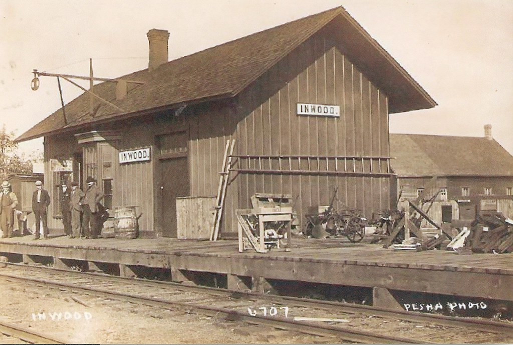 Inwood Train Station by Pesha - RPPC Inwood Train Station by Pesha - RPPC by snap-happy1, on Flickr |
|


