

Post by Steve on May 31, 2007 22:46:45 GMT -5
Well, as it turns out, this will be my first post of content related to the theme of Lost Lambton, Found... and it's fitting that this post has to do with Lambton's railway heritage, since it was my interest in the county's railways and their history, that eventually led me to an interest in other aspects of Lambton's history. I'm a long time 'railfan', having grown up next to CN's main line through Wyoming.
Because of the physical realities of constructing a railway, evidence of their existance tends to last long after they've been abandoned, giving us something to get out and hunt for. Which I've spent a lot of time doing...
This past weekend, I finally got to do a little canoeing with my good friend Mark. Over the years, we've managed to cover a good percentage of the canoeable (and plenty that shouldn't have been canoed) streams in the county. We usually cover just a few sideroads distance at a time and start again next time, from where we left off.
This time the stream was Bear Creek and the starting point was right in Petrolia. The weather was a bit iffy and the water was already getting low and the mosquitoes were already getting nasty, but this was the first chance we'd had to canoe this year, so we went for it... We put in behind C.E.E. hospital, near the golf course bridge, which is the first easy public access below the Bridgeview Park dam. Mark just likes to canoe, but I had an alterior motive; I was hoping to get some photos of the remains of an old railway bridge across the creek, just to the southwest of town.
Well, we were pretty sure the going might be tough, with the water levels already so low. We don't usually attempt Bear Creek this far upstream, except in the very early spring during freshets of melting snow or heavy springtime rains. Sure enough, we didn't get more than a few hundred feet before we hit our first logjam and it was just the first of about two dozen we'd have to either portage around, or carry over, before we reached Marthaville sideroad, which was as far as we made it before giving up this day...
But, despite having to drag the canoe almost as much as we paddled it and getting caked in the slick clay of the banks in the process, the short stretches of open channel were beautiful, with the lush new foliage and the echo of song birds and the honks of geese we kept disturbing.
Wildlife-wise, we managed to see a large brown owl, a few blue herons and many families of geese; the goslings totalling in the dozens. When encountered, one parent, as we got closer, would hurry her brood along the creek. The stragglers would dive under at the last moment, only to reappear behind us. Finally, as we got too close, with a warning honk, mom would herd the whole group out of the water to hide in the quickly thickening underbrush. Meanwhile, father would honk and play wounded, flapping weakly just ahead of us until, his ruse successful, he would alight with 'new found' strength to circle around back to his family.
We passed a number of wrecked vehicles of various vintages along the banks and eventually, we came to the spot I was hoping to see...
(click to enlarge)
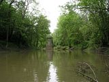
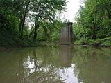
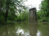
This is the spot where the Petrolia branch of the Canada Southern Railway (CASO) crossed Bear Creek. Those old enough to remember Petrolia's second railway (and the first to disappear...), likely remember it as the Michigan Central or New York Central. These are the companies who controlled and ran the CASO for most of it's existance. The Petrolia branch was built in the late 1870s and was part of the St. Clair branch, which ran from St. Thomas to Courtright. (I'll have a thread dedicated to the St. Clair branch within Lambton soon...)
My dad, who grew up in Petrolia, remembers walking down to this bridge to plink away with his .22 rifle. The entire St. Clair branch was abandoned in 1959 and the rails lifted the following year...
This was only my second time to visit this spot. The first was a few years ago, when I approached from the north along the old right-of-way, part of which has been taken over as an access road to Petrolia's sewage treatment plant and also the laneway of a private residence. On the north side of the creek, is a long, high fill, or embankment, to bring the road bed over the flood plain. It's now heavily overgrown and difficult to travel. Large concrete abutments are still to be found on both sides of the creek. I'm assuming that these and the pier are remains of a later iron bridge that likely replaced an earlier original, that was probably some type of wooden trestle.
If anyone has any other stories, or memories of this bridge, or Petrolia's railway heritage, please don't hesitate to post them.
I'm also looking for photos, plans, etc. of this bridge...
Because of the physical realities of constructing a railway, evidence of their existance tends to last long after they've been abandoned, giving us something to get out and hunt for. Which I've spent a lot of time doing...
This past weekend, I finally got to do a little canoeing with my good friend Mark. Over the years, we've managed to cover a good percentage of the canoeable (and plenty that shouldn't have been canoed) streams in the county. We usually cover just a few sideroads distance at a time and start again next time, from where we left off.
This time the stream was Bear Creek and the starting point was right in Petrolia. The weather was a bit iffy and the water was already getting low and the mosquitoes were already getting nasty, but this was the first chance we'd had to canoe this year, so we went for it... We put in behind C.E.E. hospital, near the golf course bridge, which is the first easy public access below the Bridgeview Park dam. Mark just likes to canoe, but I had an alterior motive; I was hoping to get some photos of the remains of an old railway bridge across the creek, just to the southwest of town.
Well, we were pretty sure the going might be tough, with the water levels already so low. We don't usually attempt Bear Creek this far upstream, except in the very early spring during freshets of melting snow or heavy springtime rains. Sure enough, we didn't get more than a few hundred feet before we hit our first logjam and it was just the first of about two dozen we'd have to either portage around, or carry over, before we reached Marthaville sideroad, which was as far as we made it before giving up this day...
But, despite having to drag the canoe almost as much as we paddled it and getting caked in the slick clay of the banks in the process, the short stretches of open channel were beautiful, with the lush new foliage and the echo of song birds and the honks of geese we kept disturbing.
Wildlife-wise, we managed to see a large brown owl, a few blue herons and many families of geese; the goslings totalling in the dozens. When encountered, one parent, as we got closer, would hurry her brood along the creek. The stragglers would dive under at the last moment, only to reappear behind us. Finally, as we got too close, with a warning honk, mom would herd the whole group out of the water to hide in the quickly thickening underbrush. Meanwhile, father would honk and play wounded, flapping weakly just ahead of us until, his ruse successful, he would alight with 'new found' strength to circle around back to his family.
We passed a number of wrecked vehicles of various vintages along the banks and eventually, we came to the spot I was hoping to see...
(click to enlarge)


This is the spot where the Petrolia branch of the Canada Southern Railway (CASO) crossed Bear Creek. Those old enough to remember Petrolia's second railway (and the first to disappear...), likely remember it as the Michigan Central or New York Central. These are the companies who controlled and ran the CASO for most of it's existance. The Petrolia branch was built in the late 1870s and was part of the St. Clair branch, which ran from St. Thomas to Courtright. (I'll have a thread dedicated to the St. Clair branch within Lambton soon...)
My dad, who grew up in Petrolia, remembers walking down to this bridge to plink away with his .22 rifle. The entire St. Clair branch was abandoned in 1959 and the rails lifted the following year...
This was only my second time to visit this spot. The first was a few years ago, when I approached from the north along the old right-of-way, part of which has been taken over as an access road to Petrolia's sewage treatment plant and also the laneway of a private residence. On the north side of the creek, is a long, high fill, or embankment, to bring the road bed over the flood plain. It's now heavily overgrown and difficult to travel. Large concrete abutments are still to be found on both sides of the creek. I'm assuming that these and the pier are remains of a later iron bridge that likely replaced an earlier original, that was probably some type of wooden trestle.
If anyone has any other stories, or memories of this bridge, or Petrolia's railway heritage, please don't hesitate to post them.
I'm also looking for photos, plans, etc. of this bridge...